
Marine GPS Chart Plotter - AIS9000-15
| Place of Origin: Jiangsu China (Mainland) | Brand Name: Saiyang/ OVA | Model Number: AIS9000-15 |
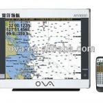

| Model | AIS9000-15 | |
| Display Size | 15" | |
| Resolution | 1024x768 | |
| Externaldimension | 272mmx305mmx100mm | |
| Display mode | TFT LCD COLOR Display | |
| Operating mode | infrared remote control | |
| Language | Simple Chinese,English,Traditional Chinese | |
| Voltage Range | 11~35V DC | |
| Power dissipation | ≤30W | |
| Safe distance of Compass | ≥1.5m | |
AIS function | Receive Frequency | 156.025-162.025MHz |
| Default Channel | CH2087,CH2088 | |
| Band Width | 25KHz | |
| Modulation Mode | GMSK | |
| Receive sensitivity | Superior to-107dBm | |
GPS Receiver | Adopt high speed stable technology | |
Positioning accuracy:<15m,95% accuracy | ||
positioning time:cold start 45s,warm start15s | ||
navigation performance | Way points:6000points | |
signs:6000points | ||
route:200routes,each route contains 99 way points | ||
track:≥200routes(way points≥60000points per route) | ||
include the tide and compass | ||
Interface | 1.GPS output:RS-422,NMEA0183,4800bps | |
2.AIS input/output:RS-422,NMEA0183,38400bps | ||
3.sonar input/output:RS-422,NMEA0183,115200bps | ||
4.GPS Antenna Interface:BNC base,impedence50Ω | ||
5.VHF Antenna Interface:UHF base,impedence50Ω | ||
6.Powerinterface:24V DC | ||
Environment | Temperature | -15°C~50°C |
| Protection Level | IP44 | |
| Certification | CCS certification | |
| Packaging Detail:Cartons |
| Delivery Detail:In three days |
Related Product for Marine GPS Chart Plotter
Radar Sart radar SART
Search and rescue radar transponder (SART) is the positioner of global maritime distress and safety system (GMDSS).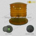
Solar Powered Led Marine Warning Light (used for aquaculture,fishery,buoy,pantoon,offshore drilling platform)
1.Manufacturer: BARGE NAVIGATION LIGHT2.Visibility range:2-3.5 nm
3.IP68,CE,ROHS,TUV,ISO9001
4.red,green,white,yellow
Marine Buoyant Smoke Signal
Marine smoke signal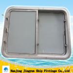
marine ship horizontal movable windows
-Place of Origin:Jiangsu China (Mainland)-Frame Material:Aluminum
-Open Style:Sliding
-Size:As standard
-Sliding flexible

rudder propeller
360 degrees steered rudder propeller is produced under Schottel technology in Germany
Ship Manhole Marine Hatch Cover
Place of Origin:Jiangsu China (Mainland)Brand Name:Zhenxing
Model Number: CB/T19-2001
Part:Hinge
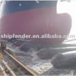
boats moving launching rubber airbag in high quality
1.High strength Anti-aging2.Good air tightness
3.Safety and reliability
4.marine airbgs used to lift huge ships
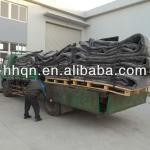
marine pneumatic rubber salvage airbag
1.ISO9001:2008,CCS2.Natural rubber, anti-aging
3.Different sizes available
4.Professional designStrict
5.Quality test
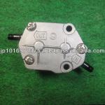
High Quality Fuel Pump for Yamaha Boat 2 Stroke Engines
Product name: Fuel Pump for outboard motorsPlace of manufacture: Japan
Applicable engine: Two stroke engine
25/40/115ps
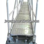
Stainless steel ship/marine ladder
Stainless steel ship/marine ladder1.ladder for ship
2.stainless steel
3.ISO9001:2008,CCS certificate
4.OEM service
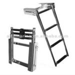
Stainless Steel 316 Under Platform Mounted Telescopic Ladder
It folds flat under your swim grid. This leaves your swim grid completely unobstructed,can easily fold out at your convenience.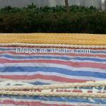
High Modulus Polyethylene Mooring Rope
High Modulus Polyethylene Mooring Rope1.Material: nylon
2.Dia: 6-150mm
3.Usage:marine rope,hawser
4.Delivery time:7days